Natchez Trace FAQ

Hundreds of cyclists use the Natchez Trace safely every year. However, you should be especially careful of the motor vehicle traffic. Please read and follow the Natchez Trace safety guidelines on the home page.
Several unique features of the Natchez Trace make this a different experience from other bike trails you might have ridden:
  • Looking at maps, you will see lots of streets and highways crossing the Trace. However, many of these crossroads are actually overpasses or underpasses, not accessible from the Trace.
  • Many sections of the Trace are quite rural and lacking in services. And some services are hard to reach, due to the fact that cross roads might be inaccessible as mentioned above. Use the Access Points feature throughout this website to help plan where you can or cannot exit the Trace. [see Access Points question below]
  • And when you do use the side roads, you will find most do not have shoulders. While cars on the Natchez Trace are more accustomed to watching for cyclists, the side road motorists are not. Most of the state and county highways look like this (images from Google Street View): Cross highway off Natchez Trace Tupelo side road off Natchez Trace
  • Because there are long stretches of road with few services, and those services can be hard to reach, advance planning is essential. Plan ahead for where you will sleep each night, where you can get your meals, and use Google Street View to trace your route to the business you expect to use - so you can verify that getting to the businesses will not be a problem. It's also a good idea to call ahead to any businesses you expect to use, to verify their hours.
  • Cyclists share the road with cars traveling upwards of 50 MPH, with little or no shoulder. Please minimize your risk by following the safety guidelines on the home page
Many of the roads that cross the Natchez Trace use overpasses or underpasses, and are therefore not accessible to cyclists from the Trace.

While you are looking at maps to plan your travel, it can be very hard to tell which roads are accessible and which are not. 
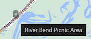
For example, while looking at a map you might decide that this looks like a great place to stop for lunch:

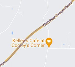
... but when you get to that road, you'll find that it's only an overpass, and the only way to get to that business is like this:


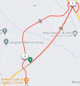
To help you avoid surprises like this, on most maps throughout this webside you'll see this option:

When this box is checked, the map will include markers to indicate where an accessible road intersects the Trace. Most of these roads don't go anywhere that you want to go, but this gives you an easy way to see which of the crossroads are even available.

indicates a road or highway
indicates a parking area or pull-off which does not connect to local roads

On a computer, you can hover your mouse over the access point to get a pop-up with the name of the crossroad or pull-off area.
You won't find many steep hills, but there are long and gradual inclines.
Take a look at the Natchez Trace elevation charts
The answer is different for every person. It depends on what speed you ride, how many miles you typically cover in a day, and how much time you take to stop and smell the roses along the way.
At 10 MPH, the 444 mile route would take 44.25 hours. But of course nobody rides at a constant pace for 44 hours straight.
Try the Natchez Trace Timeline Tool to see your expected travel time, and expected arrival times at towns along the way.
Yes you can, in certain designated locations, which are listed in the webpage at the link below. You'll need to fill out an Extended Vehicle Parking Form with the NPS.
The National Park Service does not accept any responsibility for loss or damage to your car, so do not leave any valuables behind.
Before you start your journey, and even during your journey, we recommend checking the National Park Service's webpage of Park closures, warnings, and conditions
Report problems to the National Park Service at 800-305-7417 for non-emergencies - this is the number to the Parkway Visitor Center, which is open daily from 9:00 am to 4:30 pm. To report emergencies and illegal activity, call 800-300-PARK (7275). And of course call 911 as appropriate for emergencies. Be prepared to report your location, if possible.